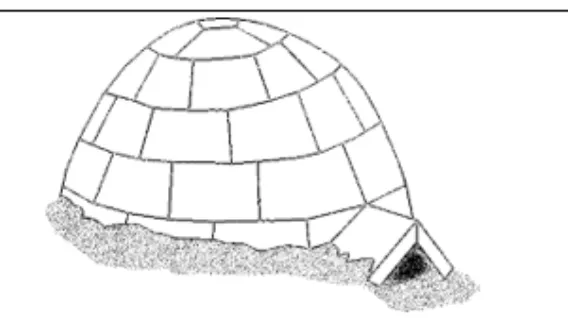
 The Inuit people of the arctic regions of North America typically have winter and summer homes. The summer dwelling is a caribou-hide tent. In winter, in regions of unrelenting cold and endless snow, it is the snow itself that furnishes thermal insulation and shelter.
For economy, simplicity, and speed of construction, the igloo may never be matched. Two people can build one in an hour, complete with skylight, using no tool other than a simple bone knife. But there is a skill to it.
Not far from prime seal-hunting grounds, Inuit people pick a clear, level spot on the frozen snow and lay out a circle ten to fifteen feet in diameter (about three to five meters). Then they carve blocks of snow from within the circle and lay them around the perimeter in an upward spiral, thus excavating and raising the walls at the same time. They pile up these snow blocks in narrowing circles until they have formed a hemisphere, with an opening left at ground level for access and another near the top.
In the higher of the two openings they put a piece of clear ice to serve as a window or a skylight. This last piece is a little harder to find, so it’s not uncommon for an Inuit family to carry around a choice piece of ice for several weeks before igloo-building time.
Once the snow-block beehive is up, the Inuit pack every crack with loose snow. Then one of them crawls through the door opening—which is designed to be just large enough for a person but too narrow for, say, a polar bear—and lights a blubber lamp inside. Feeding the lamp constantly with whale oil or seal blubber, they get a small fire started, then seal the entrance and build the fire higher.
It isn’t long before the entire igloo softens and begins to melt. Because of its hemispheric contour, the water runs down the walls instead of dripping. When the entire structure is damp, the Inuit open the entrance, and the cold blast of arctic air freezes the walls and welds the structure so solidly that nothing short of the spring thaw can damage it.
The discovery of gold in California on the western coast of North America in 1848, and the resulting migration of people to the region, had a great impact on newspapers. Throughout the gold-mining districts, almost every boomtown had its paper. Most of the mining-district papers, of course, were not published for very long, partly because of the mobility of their subscribers.
As gold poured into San Francisco, the city's financial and cultural wealth multiplied. No one made a fortune in journalism in this period, but that was largely because so many tried. By 1859, just ten years after the gold discovery, 132 periodicals were started in San Francisco alone, and the total number of their proprietors, editors, and reporters was more than 1,000. They were printed in six different languages and represented eight religious denominations and seven political parties. In 1859 there were 12 San Francisco daily newspapers, most notably the Alta California, the Herald, the Call, and the Bulletin.
Poetry, short stories, and other literary pieces often appeared in the early newspapers. The scenes of California, and the experiences of getting there and living there, were so often extraordinary and dramatic that they cried out for description. A literary weekly, the Golden Era, flourished from its first day of publication in 1852 and soon had more subscribers than any other paper on the Pacific coast. Much of its success was due to the enthusiasm of one of its young editors, Rollin M. Dagget, who traveled throughout the mining districts to sell subscriptions and also wrote many of the sketches describing the miners’ lives. Though it paid nothing for poetry and only five dollars a column for prose, nearly every writer who achieved any reputation in California during this period had taken the opportunity of publishing in it. The tone of the Golden Era was informal to the point of breeziness, and this gave it a popular appeal that enabled it to outlast a number of its competitors, including several that aspired to higher literary levels.
Two hypotheses have been proposed to explain how flight arose in birds. One hypothesis, the "trees-down" hypothesis, is that bird ancestors were tree dwellers and developed powered flight by gliding from branch to ground. The converse argument, the "ground-up" hypothesis, is that birds developed powered flight directly from a cursorial, or running, ancestor.
Evidence supporting the trees-down hypothesis relates to the inference that early birds appear to have lived in trees. This evidence comes from analysis of the beautiful fossil specimens of Archaeopteryx that preserve not only its foot bones, but also the horny claws (equivalent to human fingernails or the claws of a cat). The claws of Archaeopteryx were long and hooked. In living birds, this type of claw is typically found in birds that live in trees, suggesting that Archaeopteryx may have had similar habits. By examining fossils of the wing and shoulder, functional morphologists have inferred that it was not a skilled flyer. Hence, if it was also a tree dweller, true powered flight probably developed through an intermediate phase that involved gliding down from trees.
The ground-up hypothesis is based on phylogenetic evidence (data concerning the evolution of a genetically related group of organisms). Proponents of this hypothesis point out that the closest relatives of modern birds are dinosaurs like Deinonychus and Troodon. Because they are so closely related to birds, these dinosaurs provide direct evidence about physical characteristics of early birds. Although these dinosaurs were small by typical dinosaur standards, no one has proposed that they lived in trees or flew. Instead, they are viewed as fast-moving runners and denizens of open areas. These observations suggest that primitive birds may have been ground dwellers that developed powered flight from active running and hopping over open areas. Some scientists have even proposed that the extension and flapping of the forelimbs developed as a mechanism for swatting at prey.
Unfortunately, collecting evidence to test hypotheses about the origin of complex functional behaviors such as flight is notoriously difficult, and the problem may remain intractable until new, more powerful methods of study are developed.
One of the major problems presented by the study of the petroglyphs (carvings or inscriptions on rock) of ancient American Indian peoples is that of dating the art. Although the ability to absolutely date a particular site is rare, various methods provide a means of relative dating. Patination is one means of determining the relative ages of petroglyphs made at different times on the same cliff or boulder surface. Patina is a black or brown stain of hydrous iron and manganese oxides that forms on rock surfaces. When a petroglyph is made, the design is scratched through this layer, exposing the original color of the rock. On this exposed surface, a new layer of patina immediately begins to form. If two or more figures on a surface were made at different times, the more recent one will be lighter in color. Because patina varies with the composition of the rock and its exposure to the sun and rain, however, the degree of patination on a petroglyph alone is not an absolute guide for dating it.
The placement of rock art on a cliff face or within a rock shelter can also be an indication of age. In the river canyons of the Colorado Plateau during prehistoric times, for example, petroglyphs were sometimes made above the tops of sand dunes lying against the cliffs. The dunes were removed eventually by floods, and petroglyphs were made by subsequent canyon occupants in the scars left behind. Thus vertical stratigraphy is present today, with the oldest work on top. Similarly, ledges in rock shelters and along cliffs often enabled early artists to reach locations now inaccessible, and the work of later cultural groups, made after the ledges fell, is often present below.
Habitation debris also helps to date rock art. The art often occurs at habitation sites, which frequently can be placed within a given time frame by the pottery and other artifacts present. A useful means of ordering the chronology of certain rock art styles has been the comparison of rock art figures with those on the artifacts such as pottery, clay pipes, or wall plaster, whose age can be reliably determined by other means.
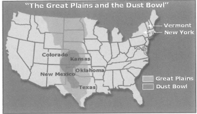
During a span of dry years in the 1930s, large dust storms plagued the Great Plains in the United States. Because of the size and severity of these storms, the region came to be called the Dust Bowl, and the time period came to be called the Dirty Thirties. The heart of the Dust Bowl consisted of nearly 100 million acres along parts of the Texas-Oklahoma border. It also included adjacent parts of Colorado, New Mexico, and Kansas. At times dust storms were so severe that they were called black blizzards and black rollers, because visibility was reduced to only a few feet. Examples of storms that lasted for hours and stripped huge volumes of topsoil from the land are numerous.
In the spring of 1934, a windstorm that lasted for a day and a half created an enormous dust cloud that extended for 2,000 kilometers. As the sediment moved east, "muddy rains" were experienced in New York, and "black snows" in Vermont. Less than a year later, another storm carried dust upward more than 3 kilometers into the atmosphere and transported it 3,000 kilometers from its source in Colorado to create twilight conditions in the middle of the day in parts of New England and New York.
What caused the Dust Bowl? Clearly, the fact that portions of the Great Plains experience some of North America's strongest winds was important. However, it was the expansion of agriculture that set the stage for the disastrous period of soil erosion. Mechanization allowed the rapid transformation of the grass-covered prairies of this semiarid region into farms. Between the 1870s and 1930, the area of cultivation in the region expanded nearly tenfold, from about 10 million acres to more than 100 million acres. As long as precipitation was adequate, the soil remained in place. However, when a prolonged drought struck in the 1930s, the unprotected fields were vulnerable to the wind. The results were severe soil loss, crop failures, and economic hardship.